Winterville, Georgia
Winterville, Georgia | |
|---|---|
| Nickname(s): The Marigold Capital of Georgia, the Friendship City[1] | |
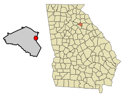
 Location in Clarke County and the state of Georgia | |
| Coordinates: 33°58′00″N 83°16′53″W / 33.96667°N 83.28139°W | |
| Country | United States |
| State | Georgia |
| County | Clarke |
| Incorporated | 1904[1] |
| Government | |
| • Mayor | Dodd Ferrelle |
| Area | |
| • Total | 2.65 sq mi (6.85 km2) |
| • Land | 2.62 sq mi (6.78 km2) |
| • Water | 0.03 sq mi (0.07 km2) |
| Elevation | 797 ft (243 m) |
| Population (2020) | |
| • Total | 1,201 |
| • Density | 458.40/sq mi (177.01/km2) |
| Time zone | UTC-5 (Eastern (EST)) |
| • Summer (DST) | UTC-4 (EDT) |
| ZIP code | 30683 |
| Area code | 706 |
| FIPS code | 13-83728[4] |
| GNIS feature ID | 2405776[3] |
| Website | cityofwinterville.com |
Winterville is a city in Clarke County, Georgia, United States. The population was 1,201 at the 2020 census.[5]
History
[edit]The community was named after John Winter, a railroad official.[6] Winterville was incorporated in 1904.[7]
Since 1991, when the City of Athens dissolved its city charter to form the unified government of Athens-Clarke County, Winterville has been the only municipality located wholly within Athens-Clarke County.
As of 2024, Athens-Clarke County has converted 1.1 miles (1.8 km) of the abandoned Athens-to—Savannah railroad spur into a paved walking trail titled "Firefly Trail".[8] It will eventually connect to the Georgia Hi–Lo Trail, which will become the longest paved trail and longest arboretum in the United States.[9]
Geography
[edit]Winterville is located at 33°58′00″N 83°16′54″W / 33.966720°N 83.281669°W,[10] a 6-mile (10 km)–drive from the University of Georgia.[1] According to the United States Census Bureau, the city has a total area of 2.7 square miles (7.0 km2), all land.
Climate
[edit]| Climate data for Winterville, Georgia, 1991–2020 normals, extremes 1999–2021 | |||||||||||||
|---|---|---|---|---|---|---|---|---|---|---|---|---|---|
| Month | Jan | Feb | Mar | Apr | May | Jun | Jul | Aug | Sep | Oct | Nov | Dec | Year |
| Record high °F (°C) | 79 (26) |
80 (27) |
89 (32) |
91 (33) |
98 (37) |
107 (42) |
106 (41) |
101 (38) |
97 (36) |
97 (36) |
83 (28) |
78 (26) |
107 (42) |
| Mean maximum °F (°C) | 70.3 (21.3) |
74.7 (23.7) |
83.2 (28.4) |
85.9 (29.9) |
89.3 (31.8) |
95.3 (35.2) |
95.2 (35.1) |
94.5 (34.7) |
90.9 (32.7) |
84.7 (29.3) |
76.9 (24.9) |
72.7 (22.6) |
97.0 (36.1) |
| Mean daily maximum °F (°C) | 54.0 (12.2) |
57.7 (14.3) |
66.3 (19.1) |
73.7 (23.2) |
79.6 (26.4) |
85.4 (29.7) |
88.3 (31.3) |
87.1 (30.6) |
82.0 (27.8) |
72.9 (22.7) |
63.1 (17.3) |
55.9 (13.3) |
72.2 (22.3) |
| Daily mean °F (°C) | 41.8 (5.4) |
45.1 (7.3) |
52.5 (11.4) |
60.2 (15.7) |
67.3 (19.6) |
74.5 (23.6) |
77.8 (25.4) |
76.8 (24.9) |
71.2 (21.8) |
60.6 (15.9) |
50.6 (10.3) |
44.1 (6.7) |
60.2 (15.7) |
| Mean daily minimum °F (°C) | 29.5 (−1.4) |
32.5 (0.3) |
38.7 (3.7) |
46.7 (8.2) |
55.0 (12.8) |
63.7 (17.6) |
67.2 (19.6) |
66.5 (19.2) |
60.4 (15.8) |
48.3 (9.1) |
38.0 (3.3) |
32.3 (0.2) |
48.2 (9.0) |
| Mean minimum °F (°C) | 16.7 (−8.5) |
21.1 (−6.1) |
25.9 (−3.4) |
33.3 (0.7) |
43.1 (6.2) |
56.9 (13.8) |
60.9 (16.1) |
61.3 (16.3) |
50.5 (10.3) |
35.5 (1.9) |
26.0 (−3.3) |
22.3 (−5.4) |
15.6 (−9.1) |
| Record low °F (°C) | 7 (−14) |
13 (−11) |
19 (−7) |
25 (−4) |
37 (3) |
45 (7) |
55 (13) |
55 (13) |
39 (4) |
27 (−3) |
18 (−8) |
14 (−10) |
7 (−14) |
| Average precipitation inches (mm) | 4.76 (121) |
4.73 (120) |
4.78 (121) |
3.65 (93) |
3.93 (100) |
4.62 (117) |
4.32 (110) |
4.77 (121) |
4.34 (110) |
3.32 (84) |
3.85 (98) |
4.71 (120) |
51.78 (1,315) |
| Average snowfall inches (cm) | 0.1 (0.25) |
0.4 (1.0) |
0.0 (0.0) |
0.0 (0.0) |
0.0 (0.0) |
0.0 (0.0) |
0.0 (0.0) |
0.0 (0.0) |
0.0 (0.0) |
0.0 (0.0) |
0.0 (0.0) |
0.1 (0.25) |
0.6 (1.5) |
| Average precipitation days (≥ 0.01 in) | 10.1 | 10.3 | 10.3 | 8.5 | 8.3 | 10.8 | 10.9 | 9.6 | 7.9 | 6.5 | 8.2 | 10.6 | 112.0 |
| Average snowy days (≥ 0.1 in) | 0.2 | 0.4 | 0.1 | 0.0 | 0.0 | 0.0 | 0.0 | 0.0 | 0.0 | 0.0 | 0.0 | 0.1 | 0.8 |
| Source 1: NOAA[11] | |||||||||||||
| Source 2: National Weather Service (mean maxima/minima 2006–2020)[12] | |||||||||||||
Demographics
[edit]| Census | Pop. | Note | %± |
|---|---|---|---|
| 1910 | 465 | — | |
| 1920 | 504 | 8.4% | |
| 1930 | 432 | −14.3% | |
| 1940 | 503 | 16.4% | |
| 1950 | 453 | −9.9% | |
| 1960 | 497 | 9.7% | |
| 1970 | 551 | 10.9% | |
| 1980 | 621 | 12.7% | |
| 1990 | 876 | 41.1% | |
| 2000 | 1,068 | 21.9% | |
| 2010 | 1,122 | 5.1% | |
| 2020 | 1,201 | 7.0% | |
| U.S. Decennial Census[13] | |||
| Race | Num. | Perc. |
|---|---|---|
| White (non-Hispanic) | 832 | 69.28% |
| Black or African American (non-Hispanic) | 220 | 18.32% |
| Asian | 21 | 1.75% |
| Pacific Islander | 1 | 0.08% |
| Other/Mixed | 46 | 3.83% |
| Hispanic or Latino | 81 | 6.74% |
As of the 2020 United States census, there were 1,201 people, 449 households, and 331 families residing in the city.
Amenities
[edit]
Winterville's Marigold Auditorium for Arts and Culture, built in 1953, fell into disrepair later in the 20th century. It has since been renovated.[15][16] The original auditorium burned down on its opening night in the early 1900s.[17]
The village's Cultural Center is located in the former high-school building, built in 1956.[18] The original high school was built at the same time as the auditorium.[17]
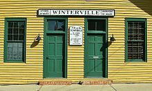
Winterville Community Center is located in a former Georgia Railroad train depot,[1] which was built in the late 19th century.[19]
Notable people
[edit]In the late 1980s, members of the neo-psychedelia rock band Butthole Surfers lived in Winterville, where they recorded their infamous third full-length LP, Locust Abortion Technician in a tiny two-bedroom home studio they rented during the summer of 1986.[20]
References
[edit]- ^ a b c d History of Winterville from the City of Winterville website. Retrieved 2014-06-19.
- ^ "2020 U.S. Gazetteer Files". United States Census Bureau. Retrieved December 18, 2021.
- ^ a b U.S. Geological Survey Geographic Names Information System: Winterville, Georgia
- ^ "U.S. Census website". United States Census Bureau. Retrieved January 31, 2008.
- ^ "Winterville city, Georgia". United States Census Bureau. Retrieved June 11, 2024.
- ^ Krakow, Kenneth K. (1975). Georgia Place-Names: Their History and Origins (PDF). Macon, GA: Winship Press. p. 255. ISBN 0-915430-00-2.
- ^ Acts and Resolutions of the General Assembly of the State of Georgia. Clark & Hines, State Printers. 1904. p. 724.
- ^ "Planned Trail". Retrieved September 11, 2024.
- ^ Countryman, Vanessa. "A 211-mile trail from Athens to Savannah will soon break ground. Here are the first steps". Savannah Morning News. Retrieved July 25, 2024.
- ^ "US Gazetteer files: 2010, 2000, and 1990". United States Census Bureau. February 12, 2011. Retrieved April 23, 2011.
- ^ "U.S. Climate Normals Quick Access – Station: Winterville, GA". National Oceanic and Atmospheric Administration. Retrieved May 11, 2023.
- ^ "NOAA Online Weather Data – NWS Atlanta". National Weather Service. Retrieved May 11, 2023.
- ^ "Census of Population and Housing". Census.gov. Retrieved June 4, 2015.
- ^ "Explore Census Data". data.census.gov. Retrieved December 18, 2021.
- ^ "Auditorium". City of Winterville. Retrieved November 17, 2023.
- ^ Bill Berry of REM performs with Winterville, Ga mayor, Dodd Ferrelle, retrieved November 17, 2023
- ^ a b Goodlett, Liza (April 28, 2018). "Winterville, GA — A Historic Town with a Bright Future". Medium. Retrieved November 17, 2023.
- ^ "Cultural Center". City of Winterville. Retrieved November 17, 2023.
- ^ "Winterville Depot". New Georgia Encyclopedia. Retrieved November 17, 2023.
- ^ Bevis, M. (August 2012). "The Weirdest Man In Show Business: Gibby Haynes Targets New Orleans". Antigravity Magazine. Retrieved June 19, 2014.
There was a rumor floating around in the '80s that the Surfers had moved to Athens, Georgia for a very specific reason. It was Winterville, but yeah we lived in Georgia.
Further reading
[edit]- Foley, Emma; Quinn, Mary (2014). Winterville, Georgia : A classic railroad town. Winterville, Georgia: Self-published by Emma Foley & Mary Quinn. ISBN 9781633180024.
External links
[edit]- History of Winterville from the City of Winterville website
 Media related to Winterville, Georgia at Wikimedia Commons


