Passaic and Harsimus Line
This article needs additional citations for verification. (September 2024) |


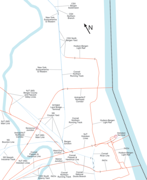
The Passaic and Harsimus Line, part of Conrail Shared Assets Operations, serves freight in northeastern New Jersey. It takes trains from the Northeast Corridor and Lehigh Line near Newark Liberty International Airport northeast and east into Jersey City. It is part of CSX's main corridor from upstate New York to the rest of the east coast.
Route description
[edit]The line begins at a junction with Amtrak's Northeast Corridor at Lane Interlocking 40°41′31″N 74°11′54″W / 40.69188°N 74.1982°W.[1] near Waverly Yard 40°41′45″N 74°11′40″W / 40.695856°N 74.194566°W. It runs next to the Northeast Corridor, just to the east, along what was originally Track 0 (the old P&H Branch east of the yard is now abandoned).
After about a mile, the Greenville Secondary splits to the east to the Lehigh Valley Railroad Bridge, and the P&H Line passes under the Lehigh Line and turns east. Access to the Lehigh Line eastbound is provided from the Greenville Branch via a track into the Oak Island Yard 40°42′31″N 74°08′17″W / 40.70867°N 74.138103°W; another track leaves the Oak Island Yard to join the P&H Line headed northbound.
After crossing the Passaic River on the Point-No-Point Bridge[2] 40°44′30″N 74°07′16″W / 40.741672°N 74.121095°W, the P&H Line passes over PATH and turns east, parallel to PATH. A track splitting just before the overpass accesses the area south of PATH. The P&H Line then heads east through West Hudson and then across the Harsimus Branch Lift Bridge over the Hackensack River to Marion Junction 40°44′16″N 74°04′25″W / 40.737665°N 74.07372°W, where the Northern Running Track goes north, with most rail traffic.
The P&H Line past Marion Junction is now a secondary connection through the Journal Square Transportation Center 40°43′56″N 74°03′47″W / 40.732141°N 74.063114°W to the National Docks Branch via a short section of the former River Line. The former River Line in Hoboken and Weehawken is now used for the Hudson-Bergen Light Rail.
History
[edit]The P&H Line, before passing to Conrail, was the Pennsylvania Railroad's P&H Line. Before that, it was the Waverly and Passaic Branch south of the bridge over PATH, the PRR's main line from there to the River Line, and the Harsimus Branch where track no longer exists, east along the Harsimus Stem Embankment to Harsimus Cove.
See also
[edit]- Timeline of Jersey City area railroads
- National Docks Secondary
- List of Hudson County railroad terminals
- List of bridges, tunnels, and cuts in Hudson County, New Jersey
- List of bridges documented by the Historic American Engineering Record in New Jersey
References
[edit]- ^ PRR Interlocking Diagram for LANE, dated Jan 1, 1968. Retrieved 12/26/2010.
- ^ "Drawbridge Operation Regulations; Passaic River, New Jersey". 12 February 1997.
External links
[edit]- Historic American Engineering Record (HAER) No. NJ-43, "Conrail Bridge" (documentation of Hackensack River lift bridge)
